Forecasting
Create Your Own Surf Forecast with Stormsurf
Mark Sponsler founded Stormsurf.com in 1998 as a way to provide the highest quality marine weather data and expert level weather analysis to anyone interested in ocean activity. Lucky for us, his inspiration came from growing up in Florida and trying to develop a way to predict the arrival of hurricane swells to his local breaks. He devoted his time to charting this information in the days before the internet, email, or wave models. All this knowledge proved valuable when he moved to San Francisco in 1995 and began to surf the famous Mavericks big wave break in Half Moon Bay. SurfScience recently spoke with Sponsler about his work and how surfers can build their own surf forecast, why surfers should know how to forecast, which tools to use and what El Nino means to you.
SurfScience: Why is it beneficial for any surfer to understand how to forecast their own waves rather than to use some of the online resources and their predictions?
Mark Sponsler: It's getting quite commonplace now for folks with a little software knowledge to be able to figure out how to use some of the automated tools to build something that sort of looks like a forecast. So there's a lot of so-called forecasts available on the web, but the quality varies from site to site. Unless you know a fair amount about the entire forecasting process, you can easily be misled, wasting a lot of time and money chasing a swell that theoretically is supposed to arrive, but never really materializes as forecast. The trick is to not use forecast projections, but only look at winds and seas that are actually occurring right at this very moment. The models tend to hype things up. But once a storm actually forms, and winds actually start to impart energy to the ocean’s surface, that's the only thing that really counts. A forecast (from the models) is just that - a projection by a bit-counting computer. It does not infer any reality to the situation. So it's important for the buyer to beware. The best insurance is a desire to learn and a natural inquisitiveness. Building a basic forecast is not too hard if you look in the right places. Stormsurf actually has a whole section in it on how to build your own forecast. A good resource for sure. In fact, most of the site is built around the notion that people want to build their own forecasts. So there are piles of resources there to help in that endeavor.
SS: For the average surfer who doesn’t know how to read this stuff, what are the charts we should pay attention to?
MS: In the end the most important tools are:
1) Buoys - because they tell you what is happening swell wise right now. And there's enough buoys off the coast of most US locations that you can get 24 hours notice before a swell even hits.
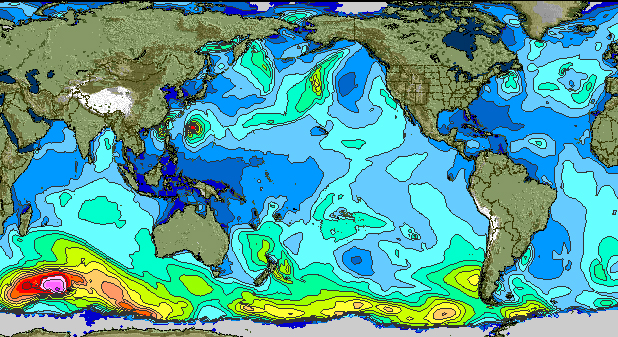
2) Wave Models, specifically a significant sea height chart - and only the 00hr image, because it depicts what is happening right now. The other forecast charts are just projections and prone to significant error.
3) If you’re really into it, the QuikSCAT satellite for confirmation of wind speeds in storms well out at sea and the Jason-1 and -2 satellites for confirmation of Significant Sea heights in those storms. This is what you need to build your own surf forecast.
SS: What do these charts tell us? In laymen’s terms, how do we read them?
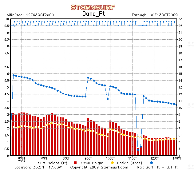
MS: The buoys are pretty self evident. But the error most folks make is they look at the significant Sea Height and period. That number provides the sum of all energy hitting the buoy at that instant in time. If there are 3 swells in the water, the significant sea height adds all of them together, providing a reading much higher than what will occur once the swell hits the coast. What you want is the "pure swell height and period" of each of those swells. Only Stormsurf and maybe one or two other sites on the web provide that data.
SS: How can we forecast wave size?
MS: Wave size is all based on the pure swell height of a single swell radiating away from a fetch (an area of strong winds). As the wind whipped seas move away from the fetch area, the choppy elements of that proto-swell, start to decay, and over time all that's left is the pure swell energy. Sort of like throwing a pebble in a pond. The pebble is the wind, and the waves radiating out away from the impact zone is the swell. There's a basic set of charts available on Stormsurf that you can use to predict the decay rate for any sized seas over distance. The longer the swell has to travel, the more it decays. But the stronger the winds are that generate that swell, the longer the resulting period will be, and the less that swell will decay. So there's relationship between wind speed, swell period and decay rate over distance.
SS: We have an upcoming El Nino. What does that mean for surfers?
MS: El Nino historically enhances the speed and configuration of the North Pacific jetstream in the Fall and Winter months, typically forming a persistent trough over the dateline pushing into the Western Gulf of Alaska. This trough provides energy and supports the development of low pressure at the oceans surface. El Nino also tends to redirect tropical systems in the far West Pacific back to the east, and when these systems hit the trough in the jet stream, they get supercharged, forming stronger and longer lasting storms than usual. So the short of it is El Nino tends to enhance Fall and Winter storm devleopment in the Northern Pacific during the years it forms, and also tends to enhance the South Pacific storm pattern the following summer. But all this is dependent upon how strong the El Nino is. A weak El Nino has much less effect, while a strong El Nino can produce too much surf and rain along the Southwest US coast. Conversely, La Nina tends to suppress the North Pacific storm patterns, but enhances the tropical patterns in the Atlantic. So El Nino is good for the Pacific from a surfing perspective, and La Nina is good for the Atlantic.
SS: What are the common misconceptions when it comes to surf reports, forecast, date and/or charts?
MS: For me, a surf report that does not include specifics about pure swell height and period, and direction is kinda worthless. What most people don't get is that the swell period is often way more important that the size of the swell itself. 2 ft @ 20 secs will get you as big or bigger of a wave than 7 ft @ 6 secs. Both result in about a 4 ft face, but with a decent bottom you can get up to 5-6 ft of face size on the longer period swell. The period (which is really a reflection of wind speed that generated the swell) is key to producing long walled up and peeling surf. Once you know the period, then you can use your local knowledge of which breaks react better to ground swell versus wind swell. Typically I try to stay away from beach breaks if the period starts exceeding 13 seconds.
SS: Many of our readers are looking to improve their surf experience and surfing skills. Will understanding how to forecast waves help this group of surfers?
MS: Good question. For beginners and intermediates surfers, the last thing they want to do is get in a situation where the surf is small, but in the middle of their session, a major ground swell starts to arrive. Here in Northern CA I've seen the surf go from 2 ft to 20 ft in a matter of 2 hours. So being on top of the forecast is essential to protecting life and limb. At a minimum, never go in the ocean if you don't have some handle on what the swell projection is for the next 12 hours. And bear in mind, often the automated wave model forecast don't pick up the early forerunners of large long period swells. So if you see a big swell coming on the charts, assume it will arrive earlier than projected. Likewise, wind swell with lesser period (8-12 sec) is a lot more forgiving than longer period surf, even in the 2-3 ft size range. So if you don't want to get hurt, or worse, try to stay away from the long period stuff.
SS: There are times when different forecasting websites will forecast different results, especially when it’s a week or more out. Why is that?
MS: So much of that has to do with the models. There is tremendous variability in the models output from one run of the model to the next, especially when the storm is just a projection on the charts. I've actually seen instances where one run of the model depicts a storm with 40 ft seas, the next run it's gone, and the run after that it's back but with only 25 ft seas. So it's a mixture of which run you’re looking at and how far in advance of its formation you are. The models are highly unstable days and weeks ahead of a storms actual formation, so take it all with a grain of salt. The only thing that really matters is real winds blowing on the ocean’s surface. Anything before that is all just conjecture by a computer. Don't bet on anything it projects. Though it's still fun to watch.
SS: Tell us about StormSurf and how surfers can use the charts and data that you offer.
MS: There's a lot of data available on Stormsurf, wave models, weather models, Buoys data, Satellite data and then a whole host of tutorials. In fact, for every product we offer there a whole set of FAQs and tutorials on what the charts are, how to read them and how to compile results and build your own forecast. I highly advise anyone who's interested in learning more about what make the waves we ride, to take a look and try to learn a little more. In the end it will make you a better surfer and make your surfing experience more enjoyable. And in the process, you'll gain a deeper appreciation for the planet and the processes that make the wave we freely enjoy. It's a beautiful world out there, all you have to do is have a desire to learn, and open your eyes to something new and different. Enjoy!
To create discover more tools, including your own surf forecast, visit Stormsurf.com





0 Comments